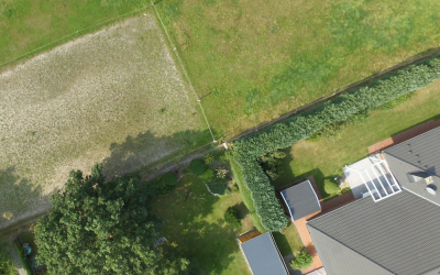
In the intricate world of property ownership, accurate boundary lines serve as the foundation for defining ownership rights and preventing disputes. However, over time, physical markers that delineate these boundaries can become obscured or altered, leaving property owners grappling with uncertainty about the true extent of their land. This is where aerial photography emerges as a beacon, illuminating previously hidden or disputed boundary lines and shedding light on the true landscape of property ownership.
The Challenges of Traditional Boundary Identification
Traditional methods of boundary identification, such as ground-level surveys and physical markers, often face limitations in providing a comprehensive and accurate picture of property lines. Dense vegetation, challenging terrain, and the passage of time can all contribute to the obscuration or alteration of markers, leaving property owners with an incomplete understanding of their boundaries. This can lead to a multitude of issues, from encroachment disputes to difficulties in land management and property valuation.
Aerial Photography: A Bird’s-Eye Perspective for Boundary Clarity
Aerial photography, with its ability to capture high-resolution images from above, offers a unique solution to unraveling the mysteries of hidden boundaries. By providing a bird’s-eye perspective that transcends the limitations of ground-level observation, aerial imagery reveals a wealth of detail that can be used to identify and trace property lines with unprecedented clarity.
Unveiling Hidden Lines: Aerial Photography’s Power of Discovery
In areas where physical markers have been obscured or altered, aerial photography proves to be an invaluable tool for uncovering previously hidden boundary lines. The ability of aerial imagery to penetrate through dense vegetation and discern subtle changes in topography allows surveyors to identify patterns and features that may have been overlooked from ground level. This newfound clarity can bring to light hidden boundary lines that may have been obscured for decades or even centuries.
Resolving Disputes: Aerial Photography as a Neutral Mediator
In the realm of property disputes, aerial photography plays a crucial role in providing neutral and objective evidence that can facilitate amicable resolutions. By presenting a clear and unbiased view of the property lines, aerial imagery can help parties involved in a dispute to better understand their respective claims and reach a mutually agreeable settlement. This can reduce the need for costly and time-consuming legal battles, saving property owners both financial and emotional distress.
The Future of Boundary Dispute Resolution: Aerial Photography Leads the Way
As technology continues to advance, aerial photography is poised to play an even more significant role in the future of boundary dispute resolution. With the development of high-resolution cameras, advanced image processing techniques, and sophisticated 3D modelling software, aerial imagery is becoming increasingly detailed and accurate, providing even clearer insights into property boundaries.
In addition, the integration of aerial photography with geographic information systems (GIS) is enabling surveyors to create comprehensive digital maps of property boundaries, providing a valuable resource for property owners, planners, and government agencies. This digital revolution in boundary identification is streamlining the process of resolving disputes, ensuring that property owners have access to accurate and up-to-date information about their land holdings.
In conclusion, aerial photography has emerged as a transformative tool in the field of boundary dispute resolution. Its ability to uncover previously hidden boundary lines, provide neutral evidence, and streamline the resolution process is revolutionising the way property owners and surveyors address boundary-related issues. As technology continues to advance, aerial photography is undoubtedly poised to play an even more prominent role in ensuring clarity, fairness, and efficiency in the world of property ownership.
Recent News & Articles
How Much Can Boundary Disputes Cost?
A boundary dispute is a disagreement between property owners or occupiers about the location of the boundary that separates their properties. Boundary disputes can arise for a number of reasons, including: Changes in property ownership: When a property is sold, the...
The Future of Boundary Dispute Resolution: Aerial Photography Leads the Way
For centuries, boundary disputes have been a persistent source of contention among property owners, often leading to strained relationships, costly legal battles, and unresolved disagreements. However, the rapid advancements in aerial photography technology are...
From Conflict to Conciliation: Aerial Photography Resolves Boundary Disputes in the UK
Boundary disputes, a persistent source of contention among property owners, have long plagued the UK landscape, leading to strained relationships, costly legal battles, and unresolved disagreements. With an estimated 6 million boundary disputes arising each year, the...


