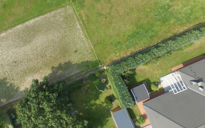
In the realm of property disputes, accurate and detailed information about property boundaries is crucial for resolving disagreements and upholding ownership rights. Traditional methods of surveying, involving ground-level measurements and physical markers, often prove inadequate in providing a comprehensive understanding of property boundaries, particularly in areas with complex topography or obscured landmarks.
This is where aerial photography emerges as a game-changer, offering a bird’s-eye perspective that unveils intricate details and provides a holistic view of property lines. By capturing high-resolution images from above, aerial photography allows surveyors and property owners to visualise boundaries with unprecedented clarity and precision.
Unveiling Hidden Boundaries: Aerial Photography Sheds Light on Property Disputes
One of the key advantages of aerial photography lies in its ability to uncover hidden or disputed boundary lines that may be difficult or impossible to detect from ground level. Overgrowth, physical obstructions, and the passage of time can obscure or alter traditional markers, leaving property owners uncertain about the true extent of their land. Aerial photography, with its sweeping vantage point, can penetrate these layers of obscurity and reveal the underlying boundary lines.
In cases where property boundaries are contested, aerial photography provides neutral and objective evidence that can help resolve disputes amicably. By presenting a clear and undisputed view of the property lines, aerial imagery can facilitate open communication and informed decision-making between parties involved in a boundary dispute.
Enhancing Accuracy and Efficiency: Aerial Photography Transforms Boundary Dispute Resolution
Aerial photography has revolutionised the process of resolving boundary disputes by offering a cost-effective and efficient alternative to traditional methods. Ground-level surveys, while valuable, can be time-consuming, labor-intensive, and prone to errors due to the challenges of navigating complex terrain and accessing difficult-to-reach areas.
Aerial photography, on the other hand, can cover vast areas in a single flight, capturing detailed imagery that can be analyzed in a fraction of the time required for ground surveys. This efficiency translates to reduced costs and faster resolution of boundary disputes, allowing property owners to move forward with confidence.
Aerial Photography: A Cornerstone of Modern Boundary Dispute Resolution
Aerial photography has become an indispensable tool for boundary dispute resolvers, providing a wealth of information that was previously inaccessible or difficult to obtain. Its ability to capture intricate details, unveil hidden boundaries, and provide a comprehensive overview of property lines has streamlined the dispute resolution process, ensuring fairer and more amicable outcomes for property owners.
As technology continues to advance, the capabilities of aerial photography are expanding further, offering even more refined imagery and enhanced data analysis tools. This evolution will undoubtedly solidify aerial photography’s position as a cornerstone of modern boundary dispute resolution, ensuring accurate, efficient, and cost-effective solutions for property owners.
If you’de like to find out more about how Sure Dispute can help with your boundary dispute, click here.
Recent News & Articles
How Much Can Boundary Disputes Cost?
A boundary dispute is a disagreement between property owners or occupiers about the location of the boundary that separates their properties. Boundary disputes can arise for a number of reasons, including: Changes in property ownership: When a property is sold, the...
The Future of Boundary Dispute Resolution: Aerial Photography Leads the Way
For centuries, boundary disputes have been a persistent source of contention among property owners, often leading to strained relationships, costly legal battles, and unresolved disagreements. However, the rapid advancements in aerial photography technology are...
From Conflict to Conciliation: Aerial Photography Resolves Boundary Disputes in the UK
Boundary disputes, a persistent source of contention among property owners, have long plagued the UK landscape, leading to strained relationships, costly legal battles, and unresolved disagreements. With an estimated 6 million boundary disputes arising each year, the...


